
Page 109 - CIWA Water Data Revolution Overview Report
P. 109
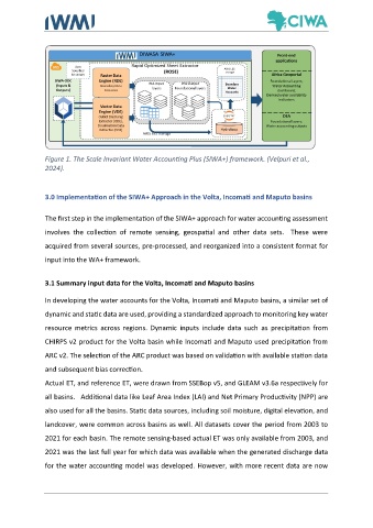
Figure 1. The Scale Invariant Water Accounting Plus (SIWA+) framework. (Velpuri et al.,
               2024).


               3.0 Implementation of the SIWA+ Approach in the Volta, Incomati and Maputo basins


               The first step in the implementation of the SIWA+ approach for water accounting assessment

               involves  the  collection  of  remote  sensing,  geospatial  and  other  data  sets.    These  were
               acquired from several sources, pre-processed, and reorganized into a consistent format for

               input into the WA+ framework.


               3.1 Summary input data for the Volta, Incomati and Maputo basins

               In developing the water accounts for the Volta, Incomati and Maputo basins, a similar set of

               dynamic and static data are used, providing a standardized approach to monitoring key water

               resource  metrics  across  regions.  Dynamic  inputs  include  data  such  as  precipitation  from
               CHIRPS v2 product for the Volta basin while Incomati and Maputo used precipitation from

               ARC v2. The selection of the ARC product was based on validation with available station data

               and subsequent bias correction.

               Actual ET, and reference ET, were drawn from SSEBop v5, and GLEAM v3.6a respectively for
               all basins.   Additional data like Leaf Area Index (LAI) and Net Primary Productivity (NPP) are

               also used for all the basins. Static data sources, including soil moisture, digital elevation, and

               landcover, were common across basins as well. All datasets cover the period from 2003 to

               2021 for each basin. The remote sensing-based actual ET was only available from 2003, and
               2021 was the last full year for which data was available when the generated discharge data

               for the water accounting model was developed. However, with more recent data are now