
Page 160 - CIWA Water Data Revolution Overview Report
P. 160
basin hydrology and highlights important hydrologic challenges in the basin.
Figure 2. The description of the basin provided
on the basin overview page
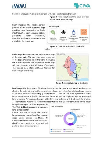
Basin Insights: The middle central
portion of the basin overview page
provides basic information on basin
insights such as basin area, population,
per-capita water availability,
environmental water stress and water
availability for future use.
Figure 3. The basic information on basin
insights
Basin Map: Here users can see an interactive map
of the river basin. The users can zoom in and out
of the basin area overlaid on the world map using
the + and – symbols. The home icon on the map
will reset the map to the full extent of the basin.
The triangle icon offers additional features for
interacting with the map.
Figure 4. Interactive map of the basin
Land usage: The distribution of land use classes across the basin are provided in a double pie
chart. In the outer pie chart, different landcover classes are reclassified into four broad classes
of land use for water accounting (LUWA) classes. 1) The Utilized land represents natural
landscapes that are utilized in their natural forms, without modifying or altering water and
land resources. For example, humans utilize forests, grasslands, and shrub lands for grazing.
2) The Managed water class represents areas that are managed for agriculture where water
is highly managed, such as irrigation. 3)
The Modified land represents area where
land is modified for
human use. For example, the natural
landscapes are cleared/modified to grow
crops under rainfed conditions. 4)
Protected land use defines the area that is
classified as protected such as national
parks or other preserved areas.