
Page 49 - CIWA Water Data Revolution Overview Report
P. 49
be combined with the existing soil moisture and surface water in the area in order to understand what the resulting
flood rates are.
8
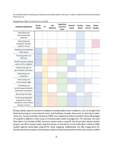
Adapted from Table 5.2 of García et al. (2016) .
Vegetation
Precip- Soil Ground- Surface Snow Water
Analytical Application ET and Land
itation Moisture water Water and Ice Quality
Cover
Identifying and
monitoring water
reservoirs
Monitoring and
prediction of water
quality in basins
Mapping and predicting
flood extent
Assessing water use
efficiency
Monitoring and mapping
water use for irrigation
Monitoring rates of
groundwater extraction
Monitoring crop
production
Monitoring and
forecasting drought
Identifying and
monitoring groundwater-
dependent ecosystems
Monitoring river flow
Conducting integrated
assessment of water
availability under climate
change scenarios
RS data allows riparian countries to address transboundary water problems, such as drought and
flood forecasting on transnational rivers, and facilitates broader discussion on sharing of water
resources. Several activities funded by CIWA have explored and demonstrated these advantages
of using RS to address critical issues in transboundary water management. For example, the Lake
Chad Basin Commission (LCBC) monitors surface water using RS, the Great Lakes Water Quality
project uses RS to analyze water pollution drivers in East Africa, and the Nile Basin Initiative (NBI)
hosted regional workshops using RS for flood mapping. Additionally, the Nile Cooperation for
Climate Resilience project is developing a regional cloud-based platform that will include a toolkit
11